


After the LA Fires, a New Research Initiative Is Trying to Create a Playbook for Soil Safety
Wildfires have always been a risk for property owners in certain parts of the country. What has changed is the scale and the geography. Between 1990 and 2020, the wildland-urban interface expanded by 179,000 square kilometers, roughly the size of Washington state. At the same time, the number of homes in these wildland-urban areas grew from 30 million to 44 million. By 2020, nearly one-third of all homes in the continental United States were in fire prone areas. CAL FIRE data show that 15 of California’s 20 most destructive wildfires by structures destroyed have occurred since 2015, including the Eaton and Palisades fires. The fires that swept through Pacific Palisades and Altadena in January 2025 were not a California anomaly. They were a preview of what the expansion of high-risk development zones into fire-prone landscapes means for property owners, insurers, and the commercial real estate industry across the country.
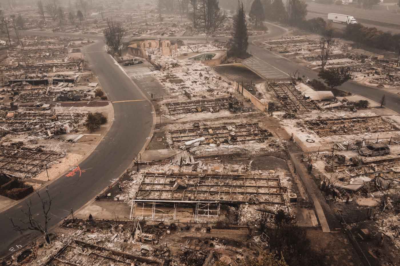
The scale of the destruction in Los Angeles was historic. Together, the Palisades and Eaton fires burned 37,469 acres, destroyed 16,264 structures, and damaged 2,051 more. More than 18 months later, the rebuilding process is gaining momentum but remains far from complete. Homeowners in Pacific Palisades are navigating permit timelines of four to seven months even for expedited like-for-like rebuilds, with full construction timelines of 22 to 34 months from total loss to occupancy. Palisades Village, the high-end open-air retail district in the heart of the neighborhood, will reopen in August 2026 after a roughly $100 million rebuilding effort by developer Rick Caruso, more than 18 months after the fire. As of early 2026, the City of LA had received over 6,600 rebuilding applications and issued more than 3,100 permits across both fires, a pace that reflects the logistical complexity of a rebuilding effort of this scale. Rebuild costs for residential properties are running $400 to $700 per square foot, meaning a standard 3,000-square-foot home in the Palisades carries a construction cost alone of $1.2 million to over $2 million before design, permitting, and engineering fees.
What the headline numbers don’t capture is the contamination problem that precedes any rebuild. When a structure burns in a wildland-urban interface fire, it doesn’t just disappear. It releases everything it contained into the surrounding environment. “Everything that gets burned up must come down,” said Eric Bollens, Chief Technology Officer at LightBox, who grew up in Pacific Palisades and whose family was personally affected by the Palisades fire. “That means that heavy metals, asbestos, and other toxins settle onto nearby properties and into the structures themselves.” For property owners, that means the question of when and whether a site is safe to rebuild on is not answered simply by debris removal. Bollens knows all of this too well, he lost his house in the Palisades Fire.
Most fire victims assume that the federal government will come to the rescue. The government’s role in cleanup, while essential, has real limitations that property owners frequently discover only after the fact. The U.S. Army Corps of Engineers conducts debris removal operations across fire-affected areas, and in the Palisades and Eaton fire recovery those operations were completed across most of the burn area by mid-2026. But government cleanup has a defined scope that does not always address the full contamination picture. “The U.S. Army Corps will clear debris but won’t do any testing,” Bollens said. “They usually scrape six inches and that usually isn’t enough, depending on what burned.” For sites where structures contained significant amounts of hazardous materials, a six-inch scrape leaves open questions about what remains in the soil beneath, questions that have direct implications for the safety of rebuilding and for the insurance and liability exposure of property owners who proceed without adequate testing.
The absence of clear, standardized guidance for what adequate testing looks like has been one of the most consequential gaps in wildfire recovery. A REBUILD community survey conducted after the January 2025 fires found that air, water, or soil testing had been conducted for less than half of responding households. Among Palisades respondents, 38.6% said they wanted testing but did not receive it. Environmental consultants working in the affected areas were being asked to advise residents and agencies without a consistent, research-backed methodology, forcing firms to develop their own approaches to sampling and remediation.
That inconsistency creates real risk, not just for individual property owners but for the credibility of the recovery process as a whole. “We see a lot of people learning about this and injecting some bad information, both from academics and from influencers,” said Andrew Whelton, Professor of Civil, Construction, and Environmental Engineering at Purdue University, who has been working with Los Angeles-area households and businesses recovering from wildfire impacts. “They made a lot of us in the scientific community really worried.”
LightBox responded to that gap in a personal and institutional way. The company donated $25,000 to a Purdue University research initiative led by Whelton to develop the Property Owner Guide for Rapidly Restoring Soil Safety after Fires, a plain-language resource intended to help property owners, environmental professionals, and government officials navigate post-fire soil contamination, debris removal, cleanup, sampling, and restoration decisions. Palisades residents Mario and Chantal Spanicciati contributed an additional $25,000, bringing total support for the initiative to $50,000. Bollens and Whelton also co-authored a Purdue paper on environmental testing of fire-impacted buildings, published in February 2026, and briefed California’s Smoke Claims and Remediation Task Force in October 2025.
The science of how to approach testing is itself more nuanced than most property owners understand going in. How a site is sampled determines how useful the results are, and poorly designed sampling can either miss contamination that is present or generate remediation costs that are disproportionate to the actual risk. “The sampling needs to be conducted well, the site needs to be broken up into different areas,” Whelton said. “This helps save property owners a lot when they know they only have to focus on one area when it comes to certain types of remediation.” That kind of targeted testing, which identifies where contamination is concentrated rather than treating an entire site as uniformly affected, can make remediation both more accurate and more cost-effective, a distinction that matters enormously when rebuild budgets are already stretched.
The longer-term vision for the work Whelton is leading goes beyond the guide itself. The combination of detailed property-level testing data, geospatial mapping, and the kind of building and land use information that companies like LightBox specialize in collecting could eventually support a much more systematic approach to understanding fire impact and directing recovery resources. “One day we should be able to create an impact map that would qualify those properties for testing,” Whelton said. “That would make it a lot easier for homeowners to query insurance companies and for insurers to understand risk.”
A data-driven impact map that identifies which properties require what types of testing and remediation, how the fire moved through the area, and what the underlying soil conditions are, would change the recovery process from a site-by-site scramble into something considerably more organized and equitable. Until that infrastructure exists, the burden falls on individual property owners to find qualified help in a market where qualified help is not always easy to identify. “The most important thing is to engage a contractor that has done this before,” Whelton said.
The fires that are reshaping how the real estate industry thinks about risk are also creating demand for better data, better science, and better coordination between the private sector and the research community. The LightBox and Purdue initiative is a small but meaningful example of what that collaboration can produce. A plain-language guide that gives property owners and environmental consultants a shared, defensible framework for soil testing and remediation doesn’t rebuild a single home on its own. But it removes one of the most consequential bottlenecks from a recovery process where every week of delay means another week a family is not home.
As the wildland-urban interface continues to expand and the frequency of major fires continues to rise, the tools that allow communities to move through recovery faster and more safely will only become more valuable. Building those tools before the next disaster, rather than scrambling to create them after, is exactly the kind of investment the industry should be making now.
The post After the LA Fires, a New Research Initiative Is Trying to Create a Playbook for Soil Safety appeared first on Propmodo.